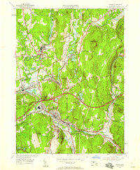
1954 Map of Palmer
USGS Topo · Published 1958About this map
The Chicopee Rivers and their tributaries define this industrial and transport corridor during the mid-1950s, where several manufacturing villages grew around water power. Settlements like Bondsville, Thorndike, and Three Rivers are densely detailed, showing the concentration of housing and mill infrastructure along the Ware River and Quaboag River. The landscape is a complex intersection of early rail lines, including the Boston and Maine Railroad and the Central Vermont Railroad, which served the local mills before the arrival of the Massachusetts Turnpike, shown here in its early years of operation.
Find a feature on this map
64 named features on this map. Tap any name to fly to it.
Don’t see what you’re looking for? This feature index may not catch every label — zoom into the map to look around manually.
Map Details
Editions of this 1954 Palmer Map
3 editions found
Other maps of this area

1887 · Brookfield
USGS Topo · 1:62,500

1887 · Palmer
USGS Topo · 1:62,500

1887 · Belchertown
USGS Topo · 1:62,500

1887 · Barre
USGS Topo · 1:62,500

1889 · Palmer
USGS Topo · 1:62,500

1889 · Barre
USGS Topo · 1:62,500

1890 · Belchertown
USGS Topo · 1:62,500

1890 · Brookfield
USGS Topo · 1:62,500

1893 · Palmer
USGS Topo · 1:62,500

1893 · Belchertown
USGS Topo · 1:62,500