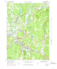
1969 Map of Palmer
USGS Topo · Published 1979About this map
Palmer serves as a critical rail junction in the late 1960s, where the Chicopee River, Ware River, Swift River, and Quaboag River converge. The industrial and transit heritage of the region is evident in the dense network of the Boston and Maine Railroad and the Central Vermont Railroad, which intersect near the village of Three Rivers. While the Massachusetts Turnpike cuts across the landscape, older local connections like Allen Rd and Old Palmer Road maintain the traditional grid between settlements like Thorndike and Bondsville. Local institutions are well-represented, from the State Hospital and Wing Memorial Hospital to the State Fish Hatchery. Genealogists will find numerous burial grounds including St Anns Cem and Oak Knoll Cem, alongside landmarks such as Mt Dumplin and the Drive-in Theater at Whipples.
Find a feature on this map
82 named features on this map. Tap any name to fly to it.
Don’t see what you’re looking for? This feature index may not catch every label — zoom into the map to look around manually.
Map Details
Editions of this 1969 Palmer Map
3 editions found
Other maps of this area

1887 · Brookfield
USGS Topo · 1:62,500

1887 · Palmer
USGS Topo · 1:62,500

1887 · Belchertown
USGS Topo · 1:62,500

1887 · Barre
USGS Topo · 1:62,500

1889 · Palmer
USGS Topo · 1:62,500

1889 · Barre
USGS Topo · 1:62,500

1890 · Belchertown
USGS Topo · 1:62,500

1890 · Brookfield
USGS Topo · 1:62,500

1893 · Palmer
USGS Topo · 1:62,500

1893 · Belchertown
USGS Topo · 1:62,500