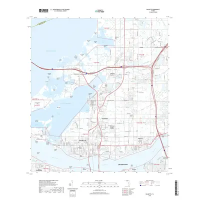
2018 Map of Palmetto
USGS Topo · Published 2018About this map
The Manatee River shoreline and the coastal labyrinths of Terra Ceia Bay anchor this 2018 study of the northern Bradenton area. The landscape is a complex mix of established citrus-era settlements and modern residential expansion. Historic communities like Palmetto and Ellenton line the northern banks of the river, while smaller hamlets like Rubonia and Gillette remain further inland. The map shows the transition from the dense urban grid of Bradenton to the rural-suburban interface near Thomson Airfield. To the west, the geography is defined by a dense network of keys and passes, including Skeet Key and Sister Keys, separated from the mainland by Williams Bayou. Significant memorial sites, including Skyway Memorial Gardens and Mansion Memorial Park, serve as local landmarks amidst the evolving infrastructure of Manatee County.
Find a feature on this map
257 named features on this map. Tap any name to fly to it.
Don’t see what you’re looking for? This feature index may not catch every label — zoom into the map to look around manually.
Map Details
Editions of this 2018 Palmetto Map
This is the sole edition of this map. No revisions or reprints were ever made.
Other maps of this area

1921 · Fort De Soto
USGS Topo · 1:62,500

1942 · Cockroach Bay
USGS Topo · 1:31,680

1943 · Pass-A-Grille
USGS Topo · 1:31,680

1944 · Anna Maria
USGS Topo · 1:31,680

1944 · Ruskin
USGS Topo · 1:31,680

1944 · Lorraine
USGS Topo · 1:31,680

1944 · Ellenton
USGS Topo · 1:31,680

1944 · Parish
USGS Topo · 1:31,680

1944 · Bradenton Beach
USGS Topo · 1:31,680

1945 · Cockroach Bay
USGS Topo · 1:31,680