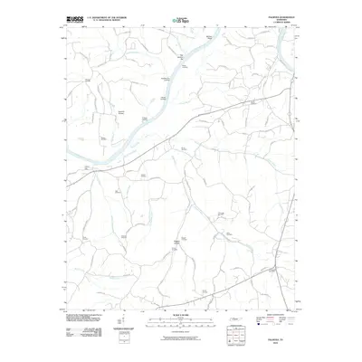
2010 Map of Palmyra
USGS Topo · Published 2010About this map
The Cumberland River carves a deep path through this Montgomery County landscape, its banks marked by a sequence of historical river access points such as O'Neals Landing, Acree Landing, and Haynes Landing. These landings, alongside river features like Martins Shoal and Sall Martins Bar, reflect a long history of water-based commerce and navigation. Inland, the terrain is defined by several hollows, including Sawmill Hollow and Baggett Hollow, which underscore the region's topographical complexity and historical timber or milling potential.
Find a feature on this map
88 named features on this map. Tap any name to fly to it.
Don’t see what you’re looking for? This feature index may not catch every label — zoom into the map to look around manually.
Map Details
Editions of this 2010 Palmyra Map
This is the sole edition of this map. No revisions or reprints were ever made.
Other maps of this area

1931 · Erin
USGS Topo · 1:62,500

1944 · Clarksville
USGS Topo · 1:50,000

1951 · New Providence
USGS Topo · 1:24,000

1951 · Clarksville
USGS Topo · 1:24,000

1951 · Woodlawn
USGS Topo · 1:24,000

1956 · Nashville
USGS Topo · 1:250,000

1957 · New Providence
USGS Topo · 1:24,000

1957 · Clarksville
USGS Topo · 1:24,000
1957 · Woodlawn
USGS Topo · 1:24,000
1957 · Clarksville
USGS Topo · 1:62,500