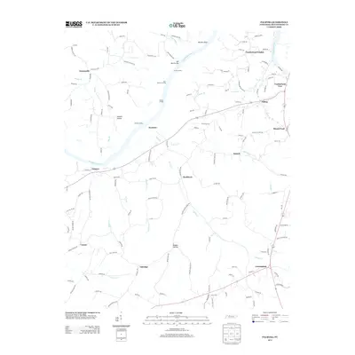
2013 Map of Palmyra
USGS Topo · Published 2013About this map
The Cumberland River carves through this portion of Montgomery County, defining the local landscape and commerce through historic river access points. Strategic riverside locations such as Acree Landing, Bud Martins Landing, and Haynes Landing signify a heritage of water-based transport and fishing, while Martins Shoal and Sall Martins Bar indicate the river's natural navigation challenges.
Find a feature on this map
136 named features on this map. Tap any name to fly to it.
Don’t see what you’re looking for? This feature index may not catch every label — zoom into the map to look around manually.
Map Details
Editions of this 2013 Palmyra Map
This is the sole edition of this map. No revisions or reprints were ever made.
Other maps of this area

1931 · Erin
USGS Topo · 1:62,500

1944 · Clarksville
USGS Topo · 1:50,000

1951 · New Providence
USGS Topo · 1:24,000

1951 · Clarksville
USGS Topo · 1:24,000

1951 · Woodlawn
USGS Topo · 1:24,000

1956 · Nashville
USGS Topo · 1:250,000

1957 · New Providence
USGS Topo · 1:24,000

1957 · Clarksville
USGS Topo · 1:24,000
1957 · Woodlawn
USGS Topo · 1:24,000
1957 · Clarksville
USGS Topo · 1:62,500