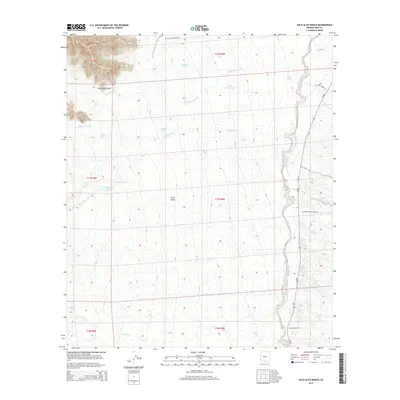
2014 Map of Palo Alto Ranch
USGS Topo · Published 2014About this map
The Coyote Mountains dominate the northwestern corner of this landscape, descending into the broad expanse of the Altar Valley. This Pima County terrain is defined by an intricate network of drainage systems, where Mendoza Canyon gives way to numerous seasonal watercourses including Alambre Wash, Brawley Wash, and Stevens Wash. Ranching infrastructure is the primary mark of human activity here, centered on the Palo Alto Ranch in the southeast. A reliance on scattered water sources is evident through the placement of man-made features like San Patricio Tank, Cactus Tank, and Ironwood Tank. Transportation across the arid basin is facilitated by specialized routes such as W Anvil Ranch Rd and the W Coyote Mountain Trl, which navigate the elevation changes between the peaks and the valley floor.
Find a feature on this map
31 named features on this map. Tap any name to fly to it.
Don’t see what you’re looking for? This feature index may not catch every label — zoom into the map to look around manually.
Map Details
Editions of this 2014 Palo Alto Ranch Map
This is the sole edition of this map. No revisions or reprints were ever made.
Other maps of this area

1920 · Arivaca
USGS Topo · 1:125,000

1934 · Tucson Mountains
USGS Topo · 1:125,000

1934 · Silver Bell
USGS Topo · 1:125,000

1938 · San Vicente
USGS Topo · 1:62,500

1940 · Palo Alto Ranch
USGS Topo · 1:62,500

1941 · San Vicente
USGS Topo · 1:62,500

1941 · Cocoraque Butte
USGS Topo · 1:62,500

1941 · Baboquivari Peak
USGS Topo · 1:62,500

1942 · San Vicente
USGS Topo · 1:62,500

1943 · Cocoraque Butte
USGS Topo · 1:62,500