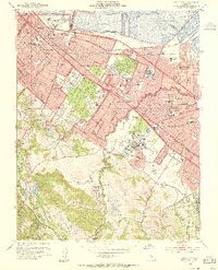
1953 Map of Palo Alto
USGS Topo · Published 1955About this map
The Mid-Peninsula landscape of the early 1950s is defined by the rapid suburbanization of Redwood City, Atherton, and Palo Alto. Along the bay front, a vast system of Salt Evaporators borders Ravenswood Slough, illustrating the industrial use of the shoreline before modern restoration efforts. Inland, the Southern Pacific railroad line anchors the commuter corridor, passing through the Menlo Park Station and the distinctive campus of Stanford University.
Find a feature on this map
107 named features on this map. Tap any name to fly to it.
Don’t see what you’re looking for? This feature index may not catch every label — zoom into the map to look around manually.
Map Details
Editions of this 1953 Palo Alto Map
2 editions found
Other maps of this area

1892 · San Mateo
USGS Topo · 1:62,500

1896 · San Mateo
USGS Topo · 1:62,500

1897 · Palo Alto
USGS Topo · 1:62,500

1899 · Palo Alto
USGS Topo · 1:62,500

1899 · Haywards
USGS Topo · 1:62,500

1899 · San Mateo
USGS Topo · 1:62,500

1902 · Santa Cruz
USGS Topo · 1:125,000

1915 · San Mateo
USGS Topo · 1:62,500

1915 · Haywards
USGS Topo · 1:62,500

1939 · San Mateo
USGS Topo · 1:62,500