
1991 Map of Palo Alto
USGS Topo · Published 1995About this map
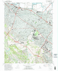
Stanford University serves as a massive focal point for this suburban landscape, featuring The Quadrangle, the Stadium, and the sprawling Linear Accelerator to the west. The 1991 survey illustrates the dense residential corridors of Redwood City, Menlo Park, and Palo Alto as they follow the Southern Pacific rail line and the historic El Camino Real.
Find a feature on this map
114 named features on this map. Tap any name to fly to it.
Don’t see what you’re looking for? This feature index may not catch every label — zoom into the map to look around manually.
Map Details
Editions of this 1991 Palo Alto Map
2 editions found
Other maps of this area

1892 · San Mateo
USGS Topo · 1:62,500

1896 · San Mateo
USGS Topo · 1:62,500

1897 · Palo Alto
USGS Topo · 1:62,500

1899 · Palo Alto
USGS Topo · 1:62,500

1899 · Haywards
USGS Topo · 1:62,500

1899 · San Mateo
USGS Topo · 1:62,500

1902 · Santa Cruz
USGS Topo · 1:125,000

1915 · San Mateo
USGS Topo · 1:62,500

1915 · Haywards
USGS Topo · 1:62,500

1939 · San Mateo
USGS Topo · 1:62,500