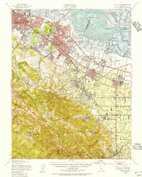
1948 Map of Palo Alto
USGS Topo · Published 1956About this map
Stanford University and the expanding residential corridors of Palo Alto anchor this mid-century survey of the San Francisco Peninsula. The landscape reflects a postwar era of rapid transition, where established estates in Atherton and Menlo Park neighbor newer suburban footprints along the Southern Pacific railroad and El Camino Real. To the north, the salt industry is visible through vast Salt Evaporators lining the San Francisco Bay shoreline near Ravenswood Slough.
Find a feature on this map
88 named features on this map. Tap any name to fly to it.
Don’t see what you’re looking for? This feature index may not catch every label — zoom into the map to look around manually.
Map Details
Editions of this 1948 Palo Alto Map
This is the sole edition of this map. No revisions or reprints were ever made.
Other maps of this area

1889 · San Jose
USGS Topo · 1:62,500

1892 · San Mateo
USGS Topo · 1:62,500

1896 · San Mateo
USGS Topo · 1:62,500

1897 · San Jose
USGS Topo · 1:62,500

1897 · Palo Alto
USGS Topo · 1:62,500

1899 · San Jose
USGS Topo · 1:62,500

1899 · Palo Alto
USGS Topo · 1:62,500

1899 · Haywards
USGS Topo · 1:62,500

1899 · San Mateo
USGS Topo · 1:62,500

1902 · Santa Cruz
USGS Topo · 1:125,000