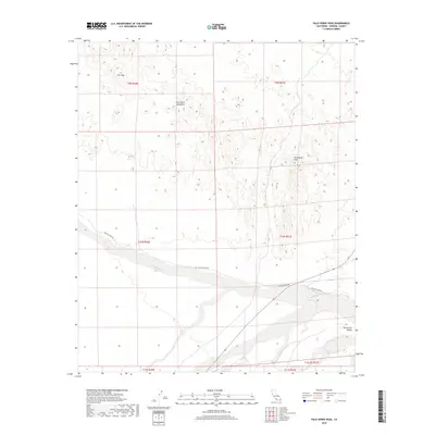
2018 Map of Palo Verde Peak
USGS Topo · Published 2018About this map
Palo Verde Peak and the surrounding Palo Verde Mountains dominate this high-desert landscape in Imperial County. The terrain is defined by the broad drainage of Milpitas Wash, which cuts a wide path across the southern half of the quadrangle. This area serves as a significant hydraulic corridor for seasonal desert runoff, influencing the placement of the sparse local infrastructure, including Milpitas Wash Rd and Walters Camp Rd. To the southeast, the open expanse of Smoketree Valley provides a stark contrast to the craggy elevations of the Flat Tops in the northwest. The map documents the intricate network of desert washes and land management divisions within the Bureau of Land Management's jurisdiction, illustrating how the natural topography of the Colorado Desert dictates the routes of travel and land use.
Find a feature on this map
14 named features on this map. Tap any name to fly to it.
Don’t see what you’re looking for? This feature index may not catch every label — zoom into the map to look around manually.
Map Details
Editions of this 2018 Palo Verde Peak Map
This is the sole edition of this map. No revisions or reprints were ever made.
Other maps of this area

1942 · Blythe
USGS Topo · 1:250,000

1945 · Cibola
USGS Topo · 1:62,500

1945 · Picacho
USGS Topo · 1:62,500

1951 · Picacho
USGS Topo · 1:62,500

1951 · Cibola
USGS Topo · 1:62,500

1952 · Palo Verde
USGS Topo · 1:24,000

1953 · Palo Verde Mountains
USGS Topo · 1:62,500

1953 · Quartz Peak
USGS Topo · 1:62,500

1954 · Salton Sea
USGS Topo · 1:250,000
1954 · Picacho NW
USGS Topo · 1:24,000