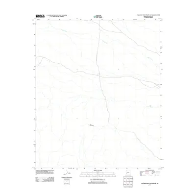
2011 Map of Palomas Mountains NW
USGS Topo · Published 2011About this map
The southern reaches of the Tank Mountains dominate this arid portion of Yuma County, where the desert landscape is defined by its complex drainage systems. Hoodoo Wash carves a significant path across the terrain, serving as the primary corridor for seasonal runoff in this unpopulated expanse. The isolation of the region is underscored by the presence of Norton to Harquahala Rd, a lonely overland route that provides one of the few points of human orientation in the area. Evidence of early water management for ranching or travel is found at White Tank, a vital resource for navigation and survival in a territory where permanent water is scarce. This topographic study reflects the stark, utilitarian character of the Arizona desert as it appeared in the early twenty-first century.
Find a feature on this map
4 named features on this map. Tap any name to fly to it.
Don’t see what you’re looking for? This feature index may not catch every label — zoom into the map to look around manually.
Map Details
Editions of this 2011 Palomas Mountains NW Map
This is the sole edition of this map. No revisions or reprints were ever made.
Other maps of this area

1942 · Vicksburg
USGS Topo · 1:250,000

1954 · Phoenix
USGS Topo · 1:250,000

1957 · Phoenix
USGS Topo · 1:250,000

1958 · Phoenix
USGS Topo · 1:250,000

1960 · Phoenix
USGS Topo · 1:250,000

1962 · Little Horn Mts
USGS Topo · 1:62,500

1962 · Kofa Butte
USGS Topo · 1:62,500
1965 · Engesser Pass
USGS Topo · 1:62,500
1965 · Palomas Mts
USGS Topo · 1:62,500

1969 · Phoenix
USGS Topo · 1:250,000