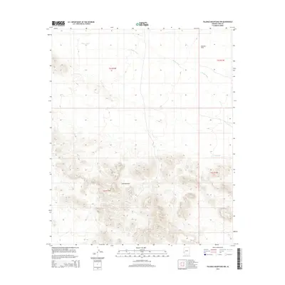
2014 Map of Palomas Mountains NW
USGS Topo · Published 2014About this map
Tank Mountains dominate the southern portion of this landscape in Yuma County, providing a stark topographical contrast to the expansive Palomas Plain to the north. This arid environment is defined by its drainage patterns, most notably Hoodoo Wash, which cuts across the northern flats. The map reveals the intricate relief of the mountain range, where narrow canyons and ridges converge toward White Tank. This 2014 survey documents a largely undeveloped corridor of the Arizona desert, where the primary identifiers are the natural terrain and the grid of the Public Land Survey System, including townships such as t2s r14w and t3s r13w. It is an essential document for understanding the hydrologic features and land divisions in this part of the Sonoran desert.
Find a feature on this map
8 named features on this map. Tap any name to fly to it.
Don’t see what you’re looking for? This feature index may not catch every label — zoom into the map to look around manually.
Map Details
Editions of this 2014 Palomas Mountains NW Map
This is the sole edition of this map. No revisions or reprints were ever made.
Other maps of this area

1942 · Vicksburg
USGS Topo · 1:250,000

1954 · Phoenix
USGS Topo · 1:250,000

1957 · Phoenix
USGS Topo · 1:250,000

1958 · Phoenix
USGS Topo · 1:250,000

1960 · Phoenix
USGS Topo · 1:250,000

1962 · Little Horn Mts
USGS Topo · 1:62,500

1962 · Kofa Butte
USGS Topo · 1:62,500
1965 · Engesser Pass
USGS Topo · 1:62,500
1965 · Palomas Mts
USGS Topo · 1:62,500

1969 · Phoenix
USGS Topo · 1:250,000