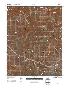
2010 Map of Pamplin
USGS Topo · Published 2010About this map
Pamplin stands as a central junction where rural roads and small crossroads settlements converge in this 2010 topographic record of the Virginia landscape. The town is surrounded by a network of smaller communities such as Hixburg, Shields, Flood, and Bowler, reflecting a classic Piedmont settlement pattern of dispersed hamlets. In the northern reaches, the Appomattox Buckingham Sf marks a significant protected woodland area, while the Appomattox River snakes through the topography, joined by numerous tributaries like Vaughans Creek and Suanee Creek. This documentation captures the modern infrastructure of Prince Edward County, showing how historical corridors like Coleman Rd and Gilliam Harvey Dr continue to define the local geography. The map is particularly useful for identifying the specific watersheds and drainage basins, including Pine Creek and Horsepen Creek, that have historically influenced the region's agricultural layout.
Find a feature on this map
23 named features on this map. Tap any name to fly to it.
Don’t see what you’re looking for? This feature index may not catch every label — zoom into the map to look around manually.
Map Details
Editions of this 2010 Pamplin Map
This is the sole edition of this map. No revisions or reprints were ever made.
Other maps of this area

1892 · Appomattox
USGS Topo · 1:125,000

1947 · Roanoke
USGS Topo · 1:250,000

1956 · Brookneal
USGS Topo · 1:62,500

1956 · Charlotte Court House
USGS Topo · 1:62,500

1958 · Appomattox
USGS Topo · 1:62,500

1958 · Pamplin City
USGS Topo · 1:62,500

1959 · Roanoke
USGS Topo · 1:250,000

1963 · Roanoke
USGS Topo · 1:250,000

1967 · Andersonville
USGS Topo · 1:24,000
1967 · Prospect
USGS Topo · 1:24,000