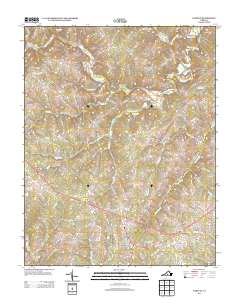
2013 Map of Pamplin
USGS Topo · Published 2013About this map
The Appomattox River winds through this central Virginia landscape, defining a rural corridor marked by historic crossroads and small settlements during the early 21st century. The town of Pamplin serves as a primary hub near the southern border, connected to outlying communities like Shields and Bowler by a network of state routes and country lanes. The map provides a detailed view of the regional hydrology, tracing the paths of numerous tributaries including Vaughans Cr and Suanee Cr.
Find a feature on this map
73 named features on this map. Tap any name to fly to it.
Don’t see what you’re looking for? This feature index may not catch every label — zoom into the map to look around manually.
Map Details
Editions of this 2013 Pamplin Map
This is the sole edition of this map. No revisions or reprints were ever made.
Other maps of this area

1892 · Appomattox
USGS Topo · 1:125,000

1947 · Roanoke
USGS Topo · 1:250,000

1956 · Brookneal
USGS Topo · 1:62,500

1956 · Charlotte Court House
USGS Topo · 1:62,500

1958 · Appomattox
USGS Topo · 1:62,500

1958 · Pamplin City
USGS Topo · 1:62,500

1959 · Roanoke
USGS Topo · 1:250,000

1963 · Roanoke
USGS Topo · 1:250,000

1967 · Andersonville
USGS Topo · 1:24,000
1967 · Prospect
USGS Topo · 1:24,000