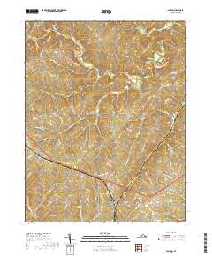
2019 Map of Pamplin
USGS Topo · Published 2019About this map
Pamplin City and the neighboring community of Pamplin serve as the central hub of this Southside Virginia landscape, situated right at the boundary of Appomattox and Prince Edward counties. The area is defined by a dense network of tributaries including Vaughans Cr, Rough Cr, and Suanee Cr, which feed north toward the winding Appomattox River. Smaller settlements like Shields, Hixburg, and Flood are connected by a web of rural routes such as Hixburg Rd and Old Grist Mill Rd, reflecting the region's agricultural and timber-based layout. The terrain is characterized by a series of ridges and creek valleys, notably around Coleman Mountain Rd. Evidence of the area's social history can be traced through the placement of landmarks like Heights School Rd, suggesting the historical locations of local rural education centers in this rolling Piedmont countryside.
Find a feature on this map
71 named features on this map. Tap any name to fly to it.
Don’t see what you’re looking for? This feature index may not catch every label — zoom into the map to look around manually.
Map Details
Editions of this 2019 Pamplin Map
This is the sole edition of this map. No revisions or reprints were ever made.
Other maps of this area

1892 · Appomattox
USGS Topo · 1:125,000

1947 · Roanoke
USGS Topo · 1:250,000

1956 · Brookneal
USGS Topo · 1:62,500

1956 · Charlotte Court House
USGS Topo · 1:62,500

1958 · Appomattox
USGS Topo · 1:62,500

1958 · Pamplin City
USGS Topo · 1:62,500

1959 · Roanoke
USGS Topo · 1:250,000

1963 · Roanoke
USGS Topo · 1:250,000

1967 · Andersonville
USGS Topo · 1:24,000
1967 · Prospect
USGS Topo · 1:24,000