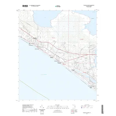
2021 Map of Panama City Beach
USGS Topo · Published 2021About this map
Panama City Beach and its string of coastal neighborhoods stretch along the Gulf of Mexico, showcasing a landscape defined by intensive waterfront development and intricate coastal water bodies. The transition from the high-density residential and resort zones like Long Beach Resort to the natural expanses of West Bay and North Bay highlights the geography of this Florida panhandle destination. The map documents a complex network of recreational trails, including the Great Nw Coastal Trail Corridor Trl and the Florida Circumnavigational Paddling Trl, which border established communities such as Open Sands and Bid-A-Wee. Inland, the terrain is marked by bayous and marshes, such as Harrison Bayou and Alligator Bayou, while the Intracoastal Waterway cuts through the northern reaches of the quadrangle, facilitating marine transit behind the protective barrier of the peninsula.
Find a feature on this map
119 named features on this map. Tap any name to fly to it.
Don’t see what you’re looking for? This feature index may not catch every label — zoom into the map to look around manually.
Map Details
Editions of this 2021 Panama City Beach Map
This is the sole edition of this map. No revisions or reprints were ever made.
Other maps of this area

1943 · Beacon Beach
USGS Topo · 1:31,680

1943 · Laguna Beach
USGS Topo · 1:31,680

1943 · Panama City
USGS Topo · 1:31,680

1943 · Panama City Beach
USGS Topo · 1:31,680

1943 · Seminole Hills
USGS Topo · 1:24,000

1943 · West Bay
USGS Topo · 1:24,000

1943 · Southport
USGS Topo · 1:24,000

1944 · Southport
USGS Topo · 1:24,000

1944 · Seminole Hills
USGS Topo · 1:31,680

1944 · West Bay
USGS Topo · 1:31,680
Featured Places
- Panama City Beach, FL
- Biltmore Beach, FL
- Lower Grand Lagoon, FL
- Gulf Lagoon Beach, FL
- Edgewater Gulf Beach, Panama City Beach