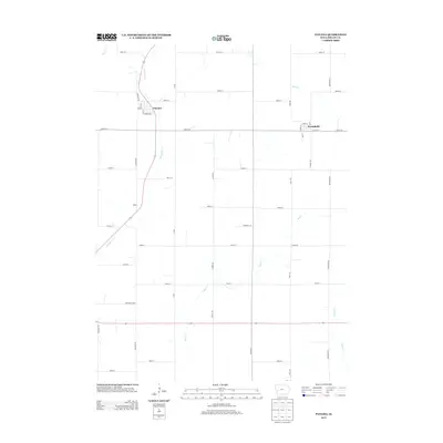
2013 Map of Panama
USGS Topo · Published 2013About this map
Panama and Westphalia anchor this portion of Shelby County, where a grid of rural roads connects scattered settlements across the Iowa landscape. The settlement of Roach sits along a bend in the road, while local life in Panama centers on streets like Fiedler Ave and Main St. The terrain is defined by a network of drainage systems, including the winding paths of Mosquito Cr, Silver Cr, and Keg Cr, which carve through the agricultural blocks.
Find a feature on this map
39 named features on this map. Tap any name to fly to it.
Don’t see what you’re looking for? This feature index may not catch every label — zoom into the map to look around manually.
Map Details
Editions of this 2013 Panama Map
This is the sole edition of this map. No revisions or reprints were ever made.
Other maps of this area

1954 · Omaha
USGS Topo · 1:250,000

1957 · Omaha
USGS Topo · 1:250,000

1958 · Omaha
USGS Topo · 1:250,000

1971 · Earling
USGS Topo · 1:24,000

1971 · Dunlap
USGS Topo · 1:24,000

1971 · Defiance
USGS Topo · 1:24,000

1978 · Panama
USGS Topo · 1:24,000

1978 · Corley
USGS Topo · 1:24,000

1978 · Persia
USGS Topo · 1:24,000
1978 · Portsmouth
USGS Topo · 1:24,000