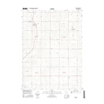
2015 Map of Panama
USGS Topo · Published 2015About this map
Panama and Westphalia anchor this portion of Shelby County, Iowa, representing the agricultural and communal heart of the region. The landscape is defined by the headwaters and drainage of several winding waterways, including Keg Cr and Mosquito Cr. A clear pattern of rural settlement is visible through the numerous township cemeteries that serve as vital landmarks for genealogical research, such as Washington Township Cem and Saint Marys Cem near Panama. The surveyed grid of gravel and paved roads, from 1000th St to the southern 900th St, illustrates the long-standing land division system. Notably, the path of Railway St in Panama suggests the historical influence of rail transport on the town's orientation, while the presence of Saint Boniface Cem in Westphalia highlights the religious foundations of these small Midwestern communities.
Find a feature on this map
35 named features on this map. Tap any name to fly to it.
Don’t see what you’re looking for? This feature index may not catch every label — zoom into the map to look around manually.
Map Details
Editions of this 2015 Panama Map
This is the sole edition of this map. No revisions or reprints were ever made.
Other maps of this area

1954 · Omaha
USGS Topo · 1:250,000

1957 · Omaha
USGS Topo · 1:250,000

1958 · Omaha
USGS Topo · 1:250,000

1971 · Earling
USGS Topo · 1:24,000

1971 · Dunlap
USGS Topo · 1:24,000

1971 · Defiance
USGS Topo · 1:24,000

1978 · Panama
USGS Topo · 1:24,000

1978 · Corley
USGS Topo · 1:24,000

1978 · Persia
USGS Topo · 1:24,000
1978 · Portsmouth
USGS Topo · 1:24,000