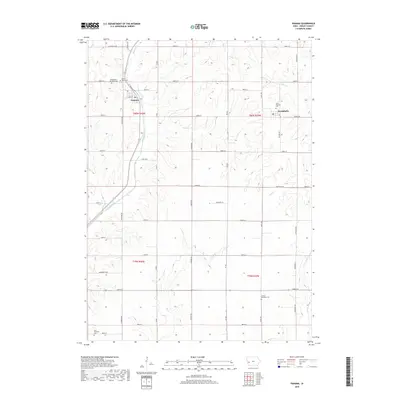
2018 Map of Panama
USGS Topo · Published 2018About this map
Panama and Westphalia anchor this portion of Shelby County, where the agricultural grid is etched into a landscape defined by the drainage of several winding creeks. The town of Panama is situated at a point where Railway St and Main St meet, while Westphalia lies to the east along Street F32. For genealogists and local historians, the map is remarkably dense with burial sites, including Saint Marys Cem and Saint Boniface Cem, alongside three larger township grounds: Washington Township Cem, Lincoln Township Cem, and Cass Township Cem. The terrain is carved by the headwaters and branches of Mosquito Cr, Silver Cr, and Keg Cr, which dictate the placement of local routes like Elmwood Loop and Dogwood Loop.
Find a feature on this map
38 named features on this map. Tap any name to fly to it.
Don’t see what you’re looking for? This feature index may not catch every label — zoom into the map to look around manually.
Map Details
Editions of this 2018 Panama Map
This is the sole edition of this map. No revisions or reprints were ever made.
Other maps of this area

1954 · Omaha
USGS Topo · 1:250,000

1957 · Omaha
USGS Topo · 1:250,000

1958 · Omaha
USGS Topo · 1:250,000

1971 · Earling
USGS Topo · 1:24,000

1971 · Dunlap
USGS Topo · 1:24,000

1971 · Defiance
USGS Topo · 1:24,000

1978 · Panama
USGS Topo · 1:24,000

1978 · Corley
USGS Topo · 1:24,000

1978 · Persia
USGS Topo · 1:24,000
1978 · Portsmouth
USGS Topo · 1:24,000