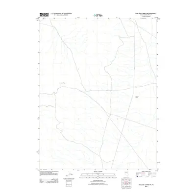
2012 Map of Pancake Summit SW
USGS Topo · Published 2012About this map
Pancake Range dominates the western portion of this Great Basin landscape in White Pine County. The topography is defined by the high, ridged terrain of the range giving way to the relatively flat expanse of the Newark Valley to the east. This 2012 survey illustrates a sparse and undeveloped environment, where the primary infrastructure consists of unpaved tracks and a segment of Co Rd-1. The network of intermittent drainage channels flowing from the slopes of the Pancake Range into the valley bottom indicates the arid hydrology typical of this Nevada region, providing a clear record of the area's natural drainage patterns before further modern alteration.
Find a feature on this map
3 named features on this map. Tap any name to fly to it.
Don’t see what you’re looking for? This feature index may not catch every label — zoom into the map to look around manually.
Map Details
Editions of this 2012 Pancake Summit SW Map
This is the sole edition of this map. No revisions or reprints were ever made.
Other maps of this area

1951 · Green Springs
USGS Topo · 1:62,500

1951 · Pancake Summit
USGS Topo · 1:62,500

1953 · Pinto Summit
USGS Topo · 1:62,500

1956 · Ely
USGS Topo · 1:250,000

1959 · Ely
USGS Topo · 1:250,000

1963 · Ely
USGS Topo · 1:250,000

1964 · Moody Peak
USGS Topo · 1:62,500

1979 · Mt. Hamilton
USGS Topo · 1:100,000

1990 · Pancake Summit SW
USGS Topo · 1:24,000
1990 · Green Springs NW
USGS Topo · 1:24,000