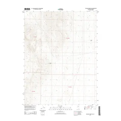
2014 Map of Pancake Summit SW
USGS Topo · Published 2014About this map
Pancake Range dominates this portion of White Pine County, showing the intricate topography of the Great Basin in the early twenty-first century. The landscape is defined by the high, ridged terrain of the range, which gives way on its eastern flank to the broader expanse of the Newark Valley. This area is sparsely developed, with human activity primarily represented by the presence of CR-1, a local connector that skirts the eastern edge of the mountains. The map provides a detailed view of the Public Land Survey System (PLSS) grid, marking the boundaries between t17n r55e, t17n r56e, and the townships to the south. The contour intervals illustrate the significant elevation changes that characterize this interior Nevada basin-and-range environment, where the relationship between high desert mountains and dry valley floors is clearly delineated.
Find a feature on this map
7 named features on this map. Tap any name to fly to it.
Don’t see what you’re looking for? This feature index may not catch every label — zoom into the map to look around manually.
Map Details
Editions of this 2014 Pancake Summit SW Map
This is the sole edition of this map. No revisions or reprints were ever made.
Other maps of this area

1951 · Green Springs
USGS Topo · 1:62,500

1951 · Pancake Summit
USGS Topo · 1:62,500

1953 · Pinto Summit
USGS Topo · 1:62,500

1956 · Ely
USGS Topo · 1:250,000

1959 · Ely
USGS Topo · 1:250,000

1963 · Ely
USGS Topo · 1:250,000

1964 · Moody Peak
USGS Topo · 1:62,500

1979 · Mt. Hamilton
USGS Topo · 1:100,000

1990 · Pancake Summit SW
USGS Topo · 1:24,000
1990 · Green Springs NW
USGS Topo · 1:24,000