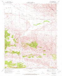
1969 Map of Panoche
USGS Topo · Published 1972About this map
Panoche Valley serves as the focal point of this late 1960s study, where the arid landscape of the Diablo Range is marked by the confluence of ranching roads and early industrial extraction. The small settlement of Panoche and the Panoche School anchor the northern valley floor near the intersection of Yturiarte Road and Panoche Road. Further south, the terrain transitions into the steep elevations of the Griswold Hills, topped by Buck Peak.
Find a feature on this map
25 named features on this map. Tap any name to fly to it.
Don’t see what you’re looking for? This feature index may not catch every label — zoom into the map to look around manually.
Map Details
Editions of this 1969 Panoche Map
2 editions found
Other maps of this area

1913 · Panoche
USGS Topo · 1:125,000

1915 · Priest Valley
USGS Topo · 1:125,000

1921 · Tierra Loma School
USGS Topo · 1:31,680

1923 · Tierra Loma School
USGS Topo · 1:31,680

1943 · New Idria
USGS Topo · 1:62,500

1943 · Hernandez Valley
USGS Topo · 1:62,500

1944 · Hernandez Valley
USGS Topo · 1:62,500

1944 · Panoche Valley
USGS Topo · 1:62,500

1948 · Santa Cruz
USGS Topo · 1:250,000

1955 · Santa Cruz
USGS Topo · 1:250,000