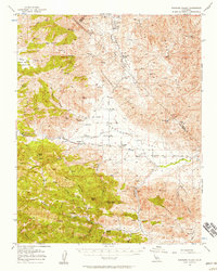
1956 Map of Panoche Valley
USGS Topo · Published 1957About this map
Mercey Hot Springs serves as a distinct point of activity in this high-desert landscape, where the Panoche Valley meets the rugged transitions of the Panoche Hills and Griswold Hills. The map details a remote agricultural and mining corridor, following Panoche Road through settlements like Llanada and the Yturiarte ranch. The presence of the Panoche School and the Strohn Ranch south of Pimental Canyon suggests a sparse but established community of ranchers and miners.
Find a feature on this map
42 named features on this map. Tap any name to fly to it.
Don’t see what you’re looking for? This feature index may not catch every label — zoom into the map to look around manually.
Map Details
Editions of this 1956 Panoche Valley Map
2 editions found
Other maps of this area

1913 · Panoche
USGS Topo · 1:125,000

1915 · Priest Valley
USGS Topo · 1:125,000

1919 · San Benito
USGS Topo · 1:62,500

1921 · Laguna Seca Ranch
USGS Topo · 1:31,680

1921 · Metz
USGS Topo · 1:62,500

1921 · Tierra Loma School
USGS Topo · 1:31,680

1922 · Quien Sabe
USGS Topo · 1:62,500

1923 · Laguna Seca Ranch
USGS Topo · 1:31,680

1923 · Tierra Loma School
USGS Topo · 1:31,680

1923 · Little Panoche
USGS Topo · 1:31,680