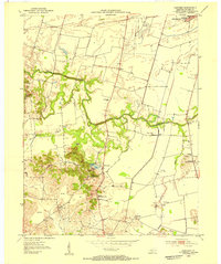
1953 Map of Panther
USGS Topo · Published 1954About this map
Panther Creek meanders across this Daviess County landscape, defining the topography between the rolling hills of the south and the flatter terrain near the Owensboro Airport to the north. In the early 1950s, this area was characterized by a rural economy of agriculture and resource extraction, visible in the numerous oil wells near Rhodes Creek and the extensive strip mines dotting the western ridges. These mining operations sit adjacent to long-established community centers like St Raphael Ch.
Find a feature on this map
32 named features on this map. Tap any name to fly to it.
Don’t see what you’re looking for? This feature index may not catch every label — zoom into the map to look around manually.
Map Details
Editions of this 1953 Panther Map
This is the sole edition of this map. No revisions or reprints were ever made.
Other maps of this area

1901 · Owensboro
USGS Topo · 1:62,500

1905 · Newburg
USGS Topo · 1:62,500

1906 · Sutherland
USGS Topo · 1:62,500

1908 · Calhoun
USGS Topo · 1:62,500

1952 · Owensboro East
USGS Topo · 1:24,000

1952 · Owensboro West
USGS Topo · 1:24,000

1952 · Reed
USGS Topo · 1:24,000

1952 · Calhoun
USGS Topo · 1:24,000

1953 · Sutherland
USGS Topo · 1:24,000

1953 · Utica
USGS Topo · 1:24,000