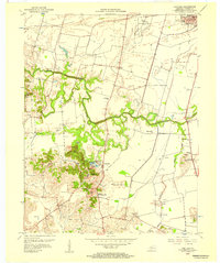
1956 Map of Panther
USGS Topo · Published 1957About this map
Panther Creek meanders through the central landscape of this Daviess County survey, defining the agricultural and industrial patterns of the mid-1950s. The southern portion of the map is heavily marked by extensive extraction activities, specifically numerous Strip Mines and clusters of Oil Wells that surround the small settlements of Panther and Mosleyville. This industrial activity contrasts with the rugged terrain of named heights like Ditney Hill and Nickel Ridge.
Find a feature on this map
38 named features on this map. Tap any name to fly to it.
Don’t see what you’re looking for? This feature index may not catch every label — zoom into the map to look around manually.
Map Details
Editions of this 1956 Panther Map
This is the sole edition of this map. No revisions or reprints were ever made.
Other maps of this area

1901 · Owensboro
USGS Topo · 1:62,500

1905 · Newburg
USGS Topo · 1:62,500

1906 · Sutherland
USGS Topo · 1:62,500

1908 · Calhoun
USGS Topo · 1:62,500

1952 · Owensboro East
USGS Topo · 1:24,000

1952 · Owensboro West
USGS Topo · 1:24,000

1952 · Reed
USGS Topo · 1:24,000

1952 · Calhoun
USGS Topo · 1:24,000

1953 · Sutherland
USGS Topo · 1:24,000

1953 · Utica
USGS Topo · 1:24,000