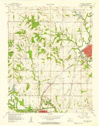
1957 Map of Paola West
USGS Topo · Published 1958About this map
The Marais Des Cygnes River flows across the southern portion of this mid-century survey, anchoring a landscape where the industrial and institutional history of Miami County is on clear display. The city of Paola serves as a major rail hub, defined by the intersection of the St Louis San Francisco, Missouri Pacific, and Missouri Kansas Texas railroads. This transportation network supported a local economy driven by scattered oil wells and regional facilities like the sprawling State Hospital and the nearby Paola Airport.
Find a feature on this map
44 named features on this map. Tap any name to fly to it.
Don’t see what you’re looking for? This feature index may not catch every label — zoom into the map to look around manually.
Map Details
Editions of this 1957 Paola West Map
2 editions found
Other maps of this area

1885 · Garnett
USGS Topo · 1:125,000

1885 · Lawrence
USGS Topo · 1:125,000

1887 · Olathe
USGS Topo · 1:125,000

1887 · Mound City
USGS Topo · 1:125,000

1889 · Lawrence
USGS Topo · 1:125,000

1893 · Mound City
USGS Topo · 1:125,000

1893 · Olathe
USGS Topo · 1:125,000

1894 · Garnett
USGS Topo · 1:125,000

1947 · Lawrence
USGS Topo · 1:250,000

1950 · Lawrence
USGS Topo · 1:250,000