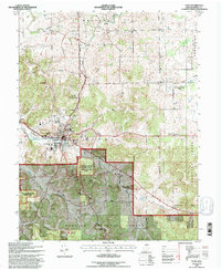
1993 Map of Paoli
USGS Topo · Published 1996About this map
The Paoli town center serves as the hub of this Indiana landscape, where the confluence of regional history and conservation is evident. To the south, the Pioneer Mothers Memorial Forest Recreation Area USFS and the Paoli Experimental Forest USFS protect large tracts of the Hoosier National Forest. The geography is defined by complex water systems, notably the Lost River to the north and the unique geological formation at the Stampers Creek Sinks. Local heritage is preserved in numerous rural sites such as Mt Pleasant Cem & Ch and Stouts Chapel. The rail infrastructure of the Monon Second Principal Meridian runs through the heart of the region, connecting the seat at Paoli to smaller outlying points like Braxtons Siding and the settlement of Syria. This map captures a transition between the established municipal grid and the sprawling forest lands that define southern Indiana.
Find a feature on this map
45 named features on this map. Tap any name to fly to it.
Don’t see what you’re looking for? This feature index may not catch every label — zoom into the map to look around manually.
Map Details
Editions of this 1993 Paoli Map
This is the sole edition of this map. No revisions or reprints were ever made.
Other maps of this area

1947 · Hardinsburg
USGS Topo · 1:24,000

1949 · Hardinsburg
USGS Topo · 1:24,000

1949 · Georgia
USGS Topo · 1:24,000

1950 · Mitchell
USGS Topo · 1:24,000

1950 · Valeene
USGS Topo · 1:24,000

1951 · French Lick
USGS Topo · 1:24,000

1951 · Georgia
USGS Topo · 1:24,000

1956 · Greenbrier
USGS Topo · 1:24,000

1956 · Vincennes
USGS Topo · 1:250,000

1957 · Vincennes
USGS Topo · 1:250,000