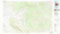
1983 Map of Paonia
USGS Topo · Published 1983About this map
Paonia and Hotchkiss serve as the primary hubs in this West Slope landscape, which is defined by the dramatic transition from high desert mesas to the high peaks of the West Elk Mountains. In the early 1980s, the local economy is visibly driven by agriculture and energy, with numerous coal operations such as the Bowie Mine and Somerset Mine clustered along the North Fork Gunnison River. The transportation network relies on the Denver and Rio Grande Western RR, which follows the river corridor to move resources from the mines through Somerset.
Find a feature on this map
76 named features on this map. Tap any name to fly to it.
Don’t see what you’re looking for? This feature index may not catch every label — zoom into the map to look around manually.
Map Details
Editions of this 1983 Paonia Map
2 editions found
Other maps of this area

1888 · Crested Butte
USGS Topo · 1:62,500

1888 · Anthracite
USGS Topo · 1:62,500

1889 · Crested Butte
USGS Topo · 1:62,500

1889 · Anthracite
USGS Topo · 1:62,500

1893 · Anthracite
USGS Topo · 1:62,500

1893 · Crested Butte
USGS Topo · 1:62,500

1893 · Aspen
USGS Topo · 1:62,500

1894 · Anthracite
USGS Topo · 1:62,500

1895 · Aspen
USGS Topo · 1:62,500

1908 · Uncompahgre
USGS Topo · 1:125,000