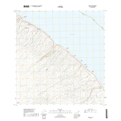
2017 Map of Papaaloa
USGS Topo · Published 2017About this map
The coastal hamlets of Laupāhoehoe, Papaaloa, and Hakalau cling to the windward Hamakua Coast of the Island of Hawai‘i, where the volcanic landscape is deeply etched by parallel drainages. Numerous watercourses, including Manowaiopae Stream and Ninole Stream, carve deep gulches as they rush toward the Pacific. The human geography is concentrated along the terrace between the sea and the upper slopes, centered on community anchors like Saint Anthony's Catholic Church and its adjacent Saint Anthony's Catholic Church Cem.
Find a feature on this map
75 named features on this map. Tap any name to fly to it.
Don’t see what you’re looking for? This feature index may not catch every label — zoom into the map to look around manually.
Map Details
Editions of this 2017 Papaaloa Map
This is the sole edition of this map. No revisions or reprints were ever made.
Other maps of this area

1915 · Hamakua
USGS Topo · 1:62,500

1915 · Honomu
USGS Topo · 1:62,500

1954 · Hawaii North
USGS Topo · 1:250,000

1956 · Pua Akala
USGS Topo · 1:24,000

1956 · Keanakolu
USGS Topo · 1:24,000

1957 · Kukaiau
USGS Topo · 1:24,000

1959 · Hawaii North
USGS Topo · 1:250,000

1961 · Hawaii North
USGS Topo · 1:250,000
1966 · Akaka Falls
USGS Topo · 1:24,000
1966 · Papaikou
USGS Topo · 1:24,000