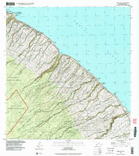
1992 Map of Papaaloa
USGS Topo · Published 2003About this map
Laupahoehoe Point and the dramatic Hamakua Coast define this landscape, where steep gulches and coastal bluffs meet the Pacific Ocean. The map reveals a complex system of agricultural homesteads, including the Manowaiopae Homesteads and Waikaumalo Maulua Homesteads, which demonstrate the historic subdivision of land for sugarcane and diversified farming above the cliffs. The settlement at Laupahoehoe is a focal point, featuring the Laupahoehoe Sch and the poignant Tidal Wave Memorial.
Find a feature on this map
43 named features on this map. Tap any name to fly to it.
Don’t see what you’re looking for? This feature index may not catch every label — zoom into the map to look around manually.
Map Details
Editions of this 1992 Papaaloa Map
This is the sole edition of this map. No revisions or reprints were ever made.
Other maps of this area

1915 · Hamakua
USGS Topo · 1:62,500

1915 · Honomu
USGS Topo · 1:62,500

1954 · Hawaii North
USGS Topo · 1:250,000

1956 · Pua Akala
USGS Topo · 1:24,000

1956 · Keanakolu
USGS Topo · 1:24,000

1957 · Kukaiau
USGS Topo · 1:24,000

1959 · Hawaii North
USGS Topo · 1:250,000

1961 · Hawaii North
USGS Topo · 1:250,000
1966 · Akaka Falls
USGS Topo · 1:24,000
1966 · Papaikou
USGS Topo · 1:24,000