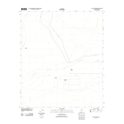
2011 Map of Papago Farms
USGS Topo · Published 2011About this map
Papago Farms occupies a distinctive geometric footprint in this arid Pima County landscape, appearing as a organized grid of fields and roads amidst the natural drainage patterns of the Sonoran Desert. The settlement of Stan Shuatuk sits just north of these agricultural lands, positioned where the terrain begins to transition toward the broader desert floor. The geography is defined by seasonal watercourses, most notably the braided reaches of Chukut Kuk Wash and San Simon Wash, which carve through the Kom Vo Valley. This 2011 survey documents a remote portion of the The Great Plain, where transportation is limited to primary corridors like Indian Rte 21 and Indian Rte 2. The map illustrates the specialized infrastructure required for desert cultivation and the persistence of small tribal communities in a region shaped by ephemeral water and vast open space.
Find a feature on this map
8 named features on this map. Tap any name to fly to it.
Don’t see what you’re looking for? This feature index may not catch every label — zoom into the map to look around manually.
Map Details
Editions of this 2011 Papago Farms Map
This is the sole edition of this map. No revisions or reprints were ever made.
Other maps of this area

1954 · Sonoyta
USGS Topo · 1:250,000

1963 · Kom Vo
USGS Topo · 1:62,500

1963 · Gu Oidak
USGS Topo · 1:62,500
1963 · La Lesna Mts.
USGS Topo · 1:62,500

1963 · Lukeville
USGS Topo · 1:250,000
1988 · Kom Vo
USGS Topo · 1:24,000
1988 · South of Bailey Peak
USGS Topo · 1:24,000
1988 · Kupk
USGS Topo · 1:24,000
1988 · Kots Kug Ranch
USGS Topo · 1:24,000
1988 · South of Papago Farms
USGS Topo · 1:24,000
Featured Places
- Stan Shuatuk, Chukut Kuk District
- Chukut Kuk District, AZ
- Pisinemo District, AZ
- Papago Farms, Chukut Kuk District
- Pima County, AZ