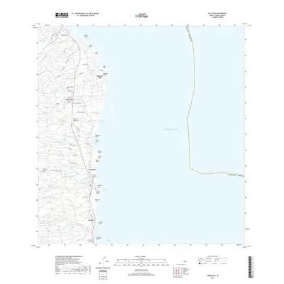
2017 Map of Papaikou
USGS Topo · Published 2017About this map
The coastal settlements of Pepeekeo, Papaikou, and Paukaa dot the Hamakua Coast in this modern survey, which details the rugged windward side of the Island of Hawai‘i. The region's plantation history is rooted at the Pepeekeo Mill and visible in the network of camp roads such as Andrade Camp Rd and Stable Camp Rd. The landscape is defined by deep gulches carved by numerous watercourses including the Honoli‘i Stream and Alakahi Stream, many of which terminate in dramatic points like Pepeekeo Point or sheltered inlets like Onomea Bay. Genealogists may find interest in Alae Cem and Mauna Kea Memorial Park located at the southern end of the quadrangle. Significant landmarks such as Onomea Arch and Waialae Falls highlight the natural geological features of this coastline where it meets the Pacific Ocean near Hilo Bay.
Find a feature on this map
77 named features on this map. Tap any name to fly to it.
Don’t see what you’re looking for? This feature index may not catch every label — zoom into the map to look around manually.
Map Details
Editions of this 2017 Papaikou Map
This is the sole edition of this map. No revisions or reprints were ever made.
Other maps of this area

1915 · Honomu
USGS Topo · 1:62,500

1917 · Hilo
USGS Topo · 1:62,500

1924 · Makuu
USGS Topo · 1:62,500

1932 · Hilo
USGS Topo · 1:62,500

1954 · Hawaii North
USGS Topo · 1:250,000

1959 · Hawaii North
USGS Topo · 1:250,000

1961 · Hawaii North
USGS Topo · 1:250,000
1963 · Piihonua
USGS Topo · 1:24,000
1963 · Hilo
USGS Topo · 1:24,000
1963 · Keaau Ranch
USGS Topo · 1:24,000