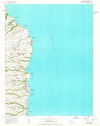
1966 Map of Papaikou
USGS Topo · Published 1967About this map
Sugar cane cultivation and coastal industry define this stretch of the Hamakua Coast during the mid-1960s. The landscape is heavily marked by the infrastructure of the plantation era, featuring numerous Flume lines that once transported cane from the upland homesteads down toward the Pepeekeo Mill at Pepeekeo Point. The map illustrates the dense network of gulches and streams, such as the Kawai Nui Stream and Pahoehoe Stream, which cut through the various ahupuaʻa and homestead divisions. Coastal settlements like Honomu, Onomea, and Papaikou are centered along the Mamalahoa Hwy, showing the transition of local commerce and residency. Notable community landmarks include Pepeekeo Sch and the Alae Cem near the southern boundary, while the northern edge touches the famous Akaka Falls State Park and the small coastal village of Wailea.
Find a feature on this map
88 named features on this map. Tap any name to fly to it.
Don’t see what you’re looking for? This feature index may not catch every label — zoom into the map to look around manually.
Map Details
Editions of this 1966 Papaikou Map
This is the sole edition of this map. No revisions or reprints were ever made.
Other maps of this area

1915 · Honomu
USGS Topo · 1:62,500

1917 · Hilo
USGS Topo · 1:62,500

1924 · Makuu
USGS Topo · 1:62,500

1932 · Hilo
USGS Topo · 1:62,500

1954 · Hawaii North
USGS Topo · 1:250,000

1959 · Hawaii North
USGS Topo · 1:250,000

1961 · Hawaii North
USGS Topo · 1:250,000
1963 · Piihonua
USGS Topo · 1:24,000
1963 · Hilo
USGS Topo · 1:24,000
1963 · Keaau Ranch
USGS Topo · 1:24,000