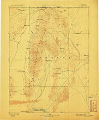
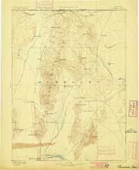
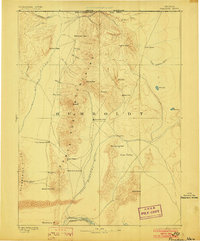
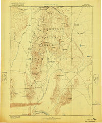
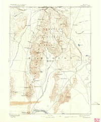
1893 Map of Paradise
USGS Topo · Published 1907About this map
Paradise City serves as the central hub of this Great Basin landscape, situated in the valley between the towering Santa Rosa Mountains and the heights of Hardscrabble. Surveyed in the early 1880s, the map documents a transition in Western transit, showing established stopping points like Cane Springs Station, Flynn Station, and Willow Point Station along the valley floor. These stations were vital links for travelers and livestock moving through the high desert of Humboldt County.
Find a feature on this map
41 named features on this map. Tap any name to fly to it.
Don’t see what you’re looking for? This feature index may not catch every label — zoom into the map to look around manually.
Map Details
Editions of this 1893 Paradise Map
6 editions found
Other maps of this area

1882 · Paradise
USGS Topo · 1:250,000

1886 · Disaster
USGS Topo · 1:250,000

1893 · Paradise
USGS Topo · 1:250,000

1893 · Disaster
USGS Topo · 1:250,000

1931 · Lovelock
USGS Topo · 1:250,000

1932 · Sonoma Range
USGS Topo · 1:250,000

1935 · Lovelock
USGS Topo · 1:250,000

1939 · Sonoma Range
USGS Topo · 1:250,000
1945 · Osgood Mountains
USGS Topo · 1:62,500
1945 · Hot Springs
USGS Topo · 1:62,500