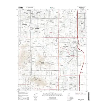
2014 Map of Paradise Valley
USGS Topo · Published 2014About this map
Mummy Mtn and the iconic Camelback Mtn anchor this modern-era portrait of the affluent residential landscape between Phoenix and Scottsdale. The 2014 survey documents a mature network of named subdivisions and planned communities, including McCormick Ranch, Gainey Ranch, and Sweetwater Ranch. The presence of the Arizona Canal and the Indian Bend Wash corridors illustrates the critical role of water management in the development of the Salt River Valley, where flood control channels and historic irrigation routes have been integrated into the urban fabric.
Find a feature on this map
55 named features on this map. Tap any name to fly to it.
Don’t see what you’re looking for? This feature index may not catch every label — zoom into the map to look around manually.
Map Details
Editions of this 2014 Paradise Valley Map
This is the sole edition of this map. No revisions or reprints were ever made.
Other maps of this area

1904 · Camelback
USGS Topo · 1:62,500

1906 · Camelsback
USGS Topo · 1:62,500

1912 · Phoenix
USGS Topo · 1:62,500

1913 · Mesa
USGS Topo · 1:62,500

1914 · Phoenix
USGS Topo · 1:62,500

1915 · Mesa
USGS Topo · 1:62,500

1930 · Cave Creek
USGS Topo · 1:125,000

1939 · Cave Creek
USGS Topo · 1:125,000

1952 · Tempe
USGS Topo · 1:24,000
1952 · Mesa
USGS Topo · 1:24,000