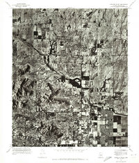
1971 Map of Paradise Valley
USGS Topo · Published 1972About this map
Paradise Valley is documented here during a period of significant suburban expansion into the desert landscape of Central Arizona. This orthophotomosaic, derived from 1971 aerial photography, provides a rare visual of the transition between the rising city centers and the surrounding terrain. The residential grid is seen pressing against the base of Mummy Mountain and Camelback Mountain, highlighting the unique intersection of early master-planned communities and the natural topography. The map details the emerging urban footprints of Scottsdale and the eastern edges of Phoenix, where agricultural lands and open desert were rapidly transforming into the modern Valley of the Sun. For local historians and genealogists, this view serves as a precise record of neighborhood development and land use before the density of later decades obscured the original desert floor.
Find a feature on this map
5 named features on this map. Tap any name to fly to it.
Don’t see what you’re looking for? This feature index may not catch every label — zoom into the map to look around manually.
Map Details
Editions of this 1971 Paradise Valley Map
This is the sole edition of this map. No revisions or reprints were ever made.
Other maps of this area

1904 · Camelback
USGS Topo · 1:62,500

1906 · Camelsback
USGS Topo · 1:62,500

1912 · Phoenix
USGS Topo · 1:62,500

1913 · Mesa
USGS Topo · 1:62,500

1914 · Phoenix
USGS Topo · 1:62,500

1915 · Mesa
USGS Topo · 1:62,500

1930 · Cave Creek
USGS Topo · 1:125,000

1939 · Cave Creek
USGS Topo · 1:125,000

1952 · Tempe
USGS Topo · 1:24,000
1952 · Mesa
USGS Topo · 1:24,000