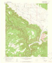
1960 Map of Paradox
USGS Topo · Published 1961About this map
Paradox Valley forms a striking geological corridor through the high plateaus of Montrose County, as documented in this 1960 revision. The small community of Paradox sits near the northern edge of the valley, supported by the Paradox Cem, while the settlement of Bedrock occupies the eastern floor where the Dolores River cuts across the landscape. The region’s mining heritage is evident in the scattered workings of the Cashin Mine, Cliffdweller Mine, and Morning Glory Mine, highlighting the mineral extraction that helped sustain these isolated outposts. Steep terrain defines the area, with Nyswonger Mesa and Wray Mesa rising sharply above the valley floor. Transportation at this time relied on a mix of unimproved dirt roads and pack routes like the Nyswonger Trail (Pack), illustrating the challenges of navigating the high mesas and deep drainages of Sharp Canyon and Wild Steer Canyon.
Find a feature on this map
22 named features on this map. Tap any name to fly to it.
Don’t see what you’re looking for? This feature index may not catch every label — zoom into the map to look around manually.
Map Details
Editions of this 1960 Paradox Map
4 editions found
Other maps of this area

1885 · La Sal
USGS Topo · 1:250,000

1916 · Paradox Valley
USGS Topo · 1:125,000

1922 · Paradox Valley
USGS Topo · 1:125,000

1948 · Roc Creek
USGS Topo · 1:24,000

1948 · Bull Canyon
USGS Topo · 1:24,000

1948 · Paradox
USGS Topo · 1:24,000

1949 · Bull Canyon
USGS Topo · 1:24,000

1949 · Davis Mesa
USGS Topo · 1:24,000

1949 · Paradox
USGS Topo · 1:24,000

1949 · Roc Creek
USGS Topo · 1:24,000