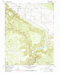
1960 Map of Paradox
USGS Topo · Published 1986About this map
Paradox Valley dominates this landscape, where the settlements of Paradox and Bedrock anchor a region defined by dramatic elevation changes and a legacy of mining. The unusual geological orientation of the valley, running perpendicular to the course of the Dolores River, is documented here alongside the vital water sources of West Paradox Creek and La Sal Creek. Near the village of Paradox, the Paradox Cem serves as a key reference for genealogical research.
Find a feature on this map
28 named features on this map. Tap any name to fly to it.
Don’t see what you’re looking for? This feature index may not catch every label — zoom into the map to look around manually.
Map Details
Editions of this 1960 Paradox Map
4 editions found
Other maps of this area

1885 · La Sal
USGS Topo · 1:250,000

1916 · Paradox Valley
USGS Topo · 1:125,000

1922 · Paradox Valley
USGS Topo · 1:125,000

1948 · Roc Creek
USGS Topo · 1:24,000

1948 · Bull Canyon
USGS Topo · 1:24,000

1948 · Paradox
USGS Topo · 1:24,000

1949 · Bull Canyon
USGS Topo · 1:24,000

1949 · Davis Mesa
USGS Topo · 1:24,000

1949 · Paradox
USGS Topo · 1:24,000

1949 · Roc Creek
USGS Topo · 1:24,000