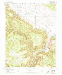
1960 Map of Paradox
USGS Topo · Published 1972About this map
The Paradox Valley floor and the surrounding high plateau of Nyswonger Mesa define this corner of western Colorado near the Utah State Line. The settlement of Paradox sits at the foot of the mesa, accompanied by the Paradox Cem and a nearby Airstrip. The landscape transitions from the broad agricultural potential of the valley to the industrial activity concentrated on the higher ground.
Find a feature on this map
23 named features on this map. Tap any name to fly to it.
Don’t see what you’re looking for? This feature index may not catch every label — zoom into the map to look around manually.
Map Details
Editions of this 1960 Paradox Map
4 editions found
Other maps of this area

1885 · La Sal
USGS Topo · 1:250,000

1916 · Paradox Valley
USGS Topo · 1:125,000

1922 · Paradox Valley
USGS Topo · 1:125,000

1948 · Roc Creek
USGS Topo · 1:24,000

1948 · Bull Canyon
USGS Topo · 1:24,000

1948 · Paradox
USGS Topo · 1:24,000

1949 · Bull Canyon
USGS Topo · 1:24,000

1949 · Davis Mesa
USGS Topo · 1:24,000

1949 · Paradox
USGS Topo · 1:24,000

1949 · Roc Creek
USGS Topo · 1:24,000