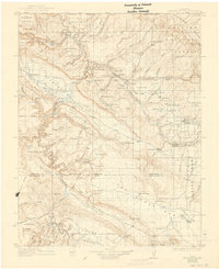
1922 Map of Paradox Valley
USGS Topo · Published 1943About this map
The Dolores River carves a winding path through this western Colorado landscape, which is defined by the unique geology of Sinbad Valley and the Long Park area. Early 20th-century mining activity is evident throughout the terrain, marked by specialized infrastructure like the Pittsburgh Mill, the Joe Junior Mill, and the Rajah Mine. The map shows a region in transition, where isolated mining camps such as Hieroglyphic Camp and Thunderbolt Camp supported the extraction of radium and uranium long before the mid-century boom.
Find a feature on this map
124 named features on this map. Tap any name to fly to it.
Don’t see what you’re looking for? This feature index may not catch every label — zoom into the map to look around manually.
Map Details
Editions of this 1922 Paradox Valley Map
2 editions found
Other maps of this area

1885 · La Sal
USGS Topo · 1:250,000

1886 · Abajo
USGS Topo · 1:250,000

1892 · Abajo
USGS Topo · 1:250,000

1893 · Abajo
USGS Topo · 1:250,000

1916 · Paradox Valley
USGS Topo · 1:125,000

1922 · Paradox Valley
USGS Topo · 1:125,000

1948 · Roc Creek
USGS Topo · 1:24,000

1948 · Bull Canyon
USGS Topo · 1:24,000

1948 · Horse Range Mesa
USGS Topo · 1:24,000

1948 · Uravan
USGS Topo · 1:24,000