
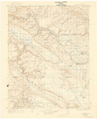
1922 Map of Paradox Valley
USGS Topo · Published 1922About this map
The San Miguel River and Dolores River carve through this Colorado landscape, revealing an era of intense resource extraction and early settlement. The map documents the carnotite mining boom, showing numerous mineral-related camps such as Julian Camp, Long Park Camp, and Thunderbolt Camp scattered across the mesas. The presence of the Cashin Mine and Cliffdweller Mine alongside the Pittsburgh Mill underscores the industrial activity that sustained local hubs like Naturita and Nucla.
Find a feature on this map
140 named features on this map. Tap any name to fly to it.
Don’t see what you’re looking for? This feature index may not catch every label — zoom into the map to look around manually.
Map Details
Editions of this 1922 Paradox Valley Map
2 editions found
Other maps of this area

1885 · La Sal
USGS Topo · 1:250,000

1886 · Abajo
USGS Topo · 1:250,000

1892 · Abajo
USGS Topo · 1:250,000

1893 · Abajo
USGS Topo · 1:250,000

1916 · Paradox Valley
USGS Topo · 1:125,000

1948 · Roc Creek
USGS Topo · 1:24,000

1948 · Bull Canyon
USGS Topo · 1:24,000

1948 · Horse Range Mesa
USGS Topo · 1:24,000

1948 · Uravan
USGS Topo · 1:24,000

1948 · Hamm Canyon
USGS Topo · 1:24,000