
2012 Map of Pardon Island
USGS Topo · Published 2012About this map
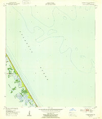
Pardon Island and the complex salt marsh estuaries of the Florida coast dominate this topographical study from 2012. The landscape is defined by the narrow barrier features and shallow waterways that separate the mainland from the Atlantic Ocean. The intricate network of tidal channels includes Pardon Slough and the broader expanse of Mosquito Lagoon, illustrating a coastline shaped by shifting sands and water. Further north, the isolated Three Cabbage Island sits among the wetlands, while Widgeon Bay marks the southern reach of the sheet. This map offers a high-resolution view of the coastal morphology and undeveloped barrier islands before significant modern alterations or natural storm-driven changes impacted the shoreline geometry.
Find a feature on this map
6 named features on this map. Tap any name to fly to it.
Don’t see what you’re looking for? This feature index may not catch every label — zoom into the map to look around manually.
Map Details
Editions of this 2012 Pardon Island Map
This is the sole edition of this map. No revisions or reprints were ever made.
Other maps of this area

1949 · Oak Hill
USGS Topo · 1:24,000

1949 · Pardon Island
USGS Topo · 1:24,000

1949 · Wilson
USGS Topo · 1:24,000

1949 · Mims
USGS Topo · 1:24,000

1950 · Ariel
USGS Topo · 1:24,000

1952 · Mims
USGS Topo · 1:24,000

1952 · Wilson
USGS Topo · 1:24,000
1952 · Pardon Island
USGS Topo · 1:24,000

1955 · Orlando
USGS Topo · 1:250,000

1957 · Orlando
USGS Topo · 1:250,000