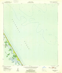
1952 Map of Pardon Island
USGS Topo · Published 1952About this map
Pardon Island and the neighboring Three Cabbage Island emerge from the waters of Mosquito Lagoon in this 1952 study of the Florida coastline. The map records a sparsely developed landscape where the small settlement of Pardon sits near the marshy edge of Pardon Slough. The intricate network of coastal waterways is detailed through features like Widgeon Bay and Scorpion, showing the primitive state of the barrier islands before significant modern development. A lone Tower stands near the boundary between Volusia and Brevard counties, marking one of the few artificial landmarks on this stretch of the Atlantic Ocean shore. This survey, compiled from 1948 aerial photography and 1949 field checks, preserves the exact topography of these shifting coastal wetlands and hammocks during the mid-century era.
Find a feature on this map
10 named features on this map. Tap any name to fly to it.
Don’t see what you’re looking for? This feature index may not catch every label — zoom into the map to look around manually.
Map Details
Editions of this 1952 Pardon Island Map
This is the sole edition of this map. No revisions or reprints were ever made.
Other maps of this area

1949 · Oak Hill
USGS Topo · 1:24,000

1949 · Pardon Island
USGS Topo · 1:24,000

1949 · Wilson
USGS Topo · 1:24,000

1949 · Mims
USGS Topo · 1:24,000

1950 · Ariel
USGS Topo · 1:24,000

1952 · Mims
USGS Topo · 1:24,000

1952 · Wilson
USGS Topo · 1:24,000

1955 · Orlando
USGS Topo · 1:250,000

1957 · Orlando
USGS Topo · 1:250,000

1958 · Orlando
USGS Topo · 1:250,000