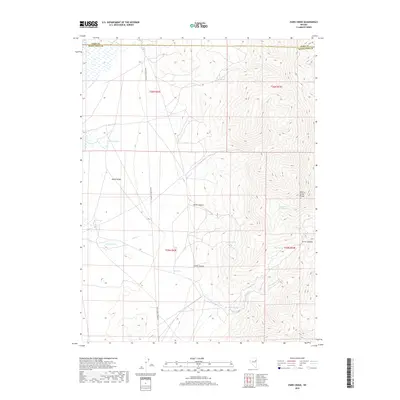
2018 Map of Paris Creek
USGS Topo · Published 2018About this map
Butte Valley and the high peaks of the Cherry Creek Range define this high-desert landscape on the border of Elko and White Pine counties. Water is the primary driver of the map's geography, with a series of named water sources like Owens Springs, Box Spring, and Petes Spring appearing along the breaks of the mountains. The presence of Dry Reservoir and seasonal drainages such as Snow Cr and Paris Cr reflect the arid character of the Great Basin, where reliable water was essential for early transit and ranching operations.
Find a feature on this map
20 named features on this map. Tap any name to fly to it.
Don’t see what you’re looking for? This feature index may not catch every label — zoom into the map to look around manually.
Map Details
Editions of this 2018 Paris Creek Map
This is the sole edition of this map. No revisions or reprints were ever made.
Other maps of this area

1955 · Elko
USGS Topo · 1:250,000

1956 · Ely
USGS Topo · 1:250,000

1958 · Elko
USGS Topo · 1:250,000

1959 · Ely
USGS Topo · 1:250,000

1962 · Elko
USGS Topo · 1:250,000

1963 · Ely
USGS Topo · 1:250,000

1965 · Elko
USGS Topo · 1:250,000

1982 · Ninemile Well
USGS Topo · 1:24,000

1982 · Exchequer Spring
USGS Topo · 1:24,000
1982 · Cherry Creek Station
USGS Topo · 1:24,000