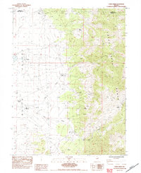
1984 Map of Paris Creek
USGS Topo · Published 1984About this map
Butte Valley serves as the vast, open floor for this high-desert landscape where the Elko and White Pine county line divides the terrain. Cattle ranching and water management define the human imprint on the land, evidenced by the presence of the Stratton Ranch, Snow Creek Ranch, and Paris Ranch. These isolated holdings rely on an intricate system of irrigation including the I. Ditch and Int. Ditch to divert water from the Cherry Creek Range into the valley below. Local history and genealogy researchers will find a small Cem near the northern boundary, alongside early infrastructure such as the Gravel Pit and scattered corrals. The transition from the flat basin to the high peaks is marked by rugged passages like Horse Canyon and the notable Currie Summit, illustrating the geography of late-twentieth-century rural Nevada before modern expansion.
Find a feature on this map
23 named features on this map. Tap any name to fly to it.
Don’t see what you’re looking for? This feature index may not catch every label — zoom into the map to look around manually.
Map Details
Editions of this 1984 Paris Creek Map
This is the sole edition of this map. No revisions or reprints were ever made.
Other maps of this area

1955 · Elko
USGS Topo · 1:250,000

1956 · Ely
USGS Topo · 1:250,000

1958 · Elko
USGS Topo · 1:250,000

1959 · Ely
USGS Topo · 1:250,000

1962 · Elko
USGS Topo · 1:250,000

1963 · Ely
USGS Topo · 1:250,000

1965 · Elko
USGS Topo · 1:250,000

1982 · Ninemile Well
USGS Topo · 1:24,000

1982 · Exchequer Spring
USGS Topo · 1:24,000
1982 · Cherry Creek Station
USGS Topo · 1:24,000