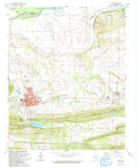
1993 Map of Paris
USGS Topo · Published 1993About this map
Paris serves as the focal point of this Logan County survey, situated just south of the Arkansas River and its wide Mc Lean Bottom. The landscape reflects a legacy of coal extraction, evidenced by numerous Mine Dumps and active shafts scattered between the town and the slopes of Short Mountain. To the east, the community of Subiaco is defined by the New Subiaco Academy and the nearby St Benedict Cem, while smaller settlements like Kalamazoo and Cotton Town dot the northern lowlands.
Find a feature on this map
47 named features on this map. Tap any name to fly to it.
Don’t see what you’re looking for? This feature index may not catch every label — zoom into the map to look around manually.
Map Details
Editions of this 1993 Paris Map
This is the sole edition of this map. No revisions or reprints were ever made.
Other maps of this area

1879 · Mountain Home
USGS Topo · 1:62,500

1887 · Magazine Mountain #1
USGS Topo · 1:62,500

1887 · Magazine Mountain #4
USGS Topo · 1:62,500

1887 · Magazine Mountain #2
USGS Topo · 1:62,500

1887 · Magazine Mountain #3
USGS Topo · 1:62,500

1887 · Magazine Mountain
USGS Topo · 1:62,500

1890 · Magazine Mountain
USGS Topo · 1:125,000

1934 · Booneville
USGS Topo · 1:48,000

1939 · Booneville
USGS Topo · 1:62,500

1956 · Russellville
USGS Topo · 1:250,000