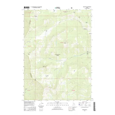
2017 Map of Paris Peak
USGS Topo · Published 2017About this map
Paris Peak and Bloomington Peak anchor this high-elevation terrain within the Cache National Forest, marking a transition between the rugged crests of the Bear River Range and the canyon-carved flats to the east. The map documents a landscape defined by seasonal hydrology and high-country travel routes, such as German Dugway Rd and Bloomington Canyon Rd. Numerous family-named and topographic landmarks like Grandy Hollow and Fourth Hollow suggest a long history of local land use. Water resources are critical in this environment, represented by isolated features like Worm Lake, Limekiln Lake, and named seeps including Worm Creek Spring and Corduroy Spring. These features, alongside wide meadows like Paris Flat and Willow Flat, illustrate the drainage patterns of the Cub River and Bloomington Cr systems as they appeared in 2017.
Find a feature on this map
42 named features on this map. Tap any name to fly to it.
Don’t see what you’re looking for? This feature index may not catch every label — zoom into the map to look around manually.
Map Details
Editions of this 2017 Paris Peak Map
This is the sole edition of this map. No revisions or reprints were ever made.
Other maps of this area

1909 · Montpelier
USGS Topo · 1:125,000

1911 · Montpelier
USGS Topo · 1:125,000

1915 · Preston
USGS Topo · 1:96,000

1918 · Preston
USGS Topo · 1:125,000

1955 · Preston
USGS Topo · 1:250,000

1958 · Preston
USGS Topo · 1:250,000

1962 · Preston
USGS Topo · 1:250,000

1967 · Paris
USGS Topo · 1:24,000

1967 · Ovid
USGS Topo · 1:24,000
1969 · Midnight Mtn
USGS Topo · 1:24,000