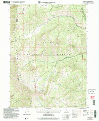
2005 Map of Paris Peak
USGS Topo · Published 2007About this map
The Bear Lake Range defines the high-elevation landscape of this 2005 revision, where the Cache National Forest spans the divide between Franklin and Bear Lake counties. This terrain is characterized by deep limestone drainages and unique geological formations, most notably the Paris Ice Cave and the high alpine Bloomington Lake tucked beneath Bloomington Peak.
Find a feature on this map
37 named features on this map. Tap any name to fly to it.
Don’t see what you’re looking for? This feature index may not catch every label — zoom into the map to look around manually.
Map Details
Editions of this 2005 Paris Peak Map
This is the sole edition of this map. No revisions or reprints were ever made.
Other maps of this area

1909 · Montpelier
USGS Topo · 1:125,000

1911 · Montpelier
USGS Topo · 1:125,000

1915 · Preston
USGS Topo · 1:96,000

1918 · Preston
USGS Topo · 1:125,000

1955 · Preston
USGS Topo · 1:250,000

1958 · Preston
USGS Topo · 1:250,000

1962 · Preston
USGS Topo · 1:250,000

1967 · Paris
USGS Topo · 1:24,000

1967 · Ovid
USGS Topo · 1:24,000
1969 · Midnight Mtn
USGS Topo · 1:24,000