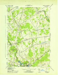
1943 Map of Parishville
USGS Topo · Published 1943About this map
Parishville and the surrounding townships of Stockholm and Hopkinton are defined by the winding course of the St Regis River in this mid-century survey. The landscape is a network of small agricultural and river-dependent settlements, where the river's descent is marked by the Allens Falls and the containment of the Allens Falls Reservoir. This era shows a community structured around a decentralized education system, evidenced by numerous district schoolhouses such as School No 1, Sch No 18, and School No 14 scattered along rural routes like Old Forge Road and Sullivan Road. Genealogists will find significant value in the documentation of local burial grounds, including Fairview Cem, Union Cem, and Hillcrest Cem, which served the families of now-quiet locales like Southville and Beechertown.
Find a feature on this map
40 named features on this map. Tap any name to fly to it.
Don’t see what you’re looking for? This feature index may not catch every label — zoom into the map to look around manually.
Map Details
Editions of this 1943 Parishville Map
2 editions found
Other maps of this area

1906 · Massena
USGS Topo · 1:62,500

1907 · Massena
USGS Topo · 1:62,500

1908 · Potsdam
USGS Topo · 1:62,500

1915 · Moira
USGS Topo · 1:62,500

1917 · Moira
USGS Topo · 1:62,500

1919 · Nicholville
USGS Topo · 1:62,500

1921 · Nicholville
USGS Topo · 1:62,500

1942 · Long Bow
USGS Topo · 1:24,000

1942 · Norfolk
USGS Topo · 1:24,000

1943 · Potsdam
USGS Topo · 1:31,680