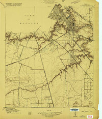
1915 Map of Park Place
USGS Topo · Published 1915About this map
The industrial and residential expansion of the southeast City of Houston is documented here just as the Ship Channel was beginning to transform the local economy. The gridded streets of Magnolia Park sit at the edge of the Turning Basin, marking the northern limit of a landscape defined by meandering waterways and new rail infrastructure. South of the city, the winding courses of Brays Bayou and Sims Bayou cut through the coastal plain, creating natural boundaries for developing neighborhoods such as Brookline, Forest Hills, and Park Place.
Find a feature on this map
30 named features on this map. Tap any name to fly to it.
Don’t see what you’re looking for? This feature index may not catch every label — zoom into the map to look around manually.
Map Details
Editions of this 1915 Park Place Map
2 editions found
Other maps of this area

1915 · Bellaire
USGS Topo · 1:24,000

1915 · Park Place
USGS Topo · 1:24,000

1915 · Houston Heights
USGS Topo · 1:24,000

1915 · Deepwater
USGS Topo · 1:24,000

1916 · Genoa
USGS Topo · 1:24,000

1916 · Settegast
USGS Topo · 1:24,000

1916 · Fauna
USGS Topo · 1:24,000

1919 · Deepwater
USGS Topo · 1:31,680

1920 · Genoa
USGS Topo · 1:31,680
1920 · Fauna
USGS Topo · 1:31,680